
Our Intelligent Marine and Aerial Platforms
At MAKI, we do not just design, develop, and build unmanned systems. We also operate them in the field. This means our clients do not need to worry about training, maintenance, or operations. We provide full-service deployment that’s cost-effective and highly reliable.
Our team is one of the few capable of delivering both aerial and water-based mapping in a single mission. This allows us to stitch together top-down terrain models with precise bathymetric data, offering a complete view of the environment, above and below the surface.
Our in-house engineering team has developed a range of advanced surface and underwater vehicles, and we also integrate best-in-class commercial drones while retaining full capability to custom-build aerial systems if required.
MAKI SkyDrop
Waterproof Sampling Drone (SwellPro)
SkyDrop is based on the SwellPro platform — a waterproof drone that can take off from and land on water. It enables rapid water sampling from isolated or hazardous areas like ponds, flood zones, and sediment basins. While we use SwellPro for efficiency, MAKI can develop custom aerial sampling drones where required.
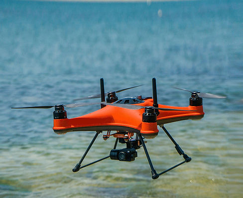
MAKI AeroMap
Aerial 3D Mapping & Photogrammetry (DJI Matrice 4E)
AeroMap is powered by the DJI Matrice 4E — an enterprise-level drone for high-resolution terrain modelling and photogrammetry. It is ideal for land-use planning, construction, and environmental monitoring. Because we also perform water-based mapping, MAKI can seamlessly merge aerial data with bathymetric maps collected during the same mission, providing one unified model across land and water.


MAKI boat V1 - Hydromap
Autonomous Bathymetry USV
Hydromap is MAKI’s original in-house designed unmanned surface vessel for lake and pond bathymetry. It collects high-resolution sonar data for depth profiling, sedimentation assessment, and pond management. Hydromap remains a reliable and efficient tool for waterbody mapping.
MAKI boat V2 - Hydrohub
Smart USV for Water Sampling, Monitoring & Bathymetry
Hydrohub is MAKI’s most advanced USV, designed and built entirely in-house. It performs real-time water quality monitoring, multi-point sampling, and bathymetric mapping using sonar and GPS. With sensor deployment via winch and multiple sampling valves, Hydrohub can deliver robust data from even the most remote or contaminated waters.
Paired with AeroMap, Hydrohub’s bathymetry data can be stitched directly into the same 3D model, giving clients a full environmental view for both above and below the surface.


MAKI DeepView
Remotely Operated Vehicle (ROV)
DeepView is MAKI’s underwater inspection tool, used for dam walls, nets, pipes, or submerged structures. It provides live video and sonar in real time. While we currently operate a commercial ROV, we also have the in-house capability to design and build custom underwater platforms for inspection, mapping, or intervention.
MAKI MicroScan
Compact Sonar Boat for Tight & Shallow Areas
MicroScan is a lightweight, remote-controlled surface vessel fitted with a sonar system. It is perfect for tight or shallow water bodies like drainage ponds, culverts, sediment basins, and confined urban waterways. Its small size and quick deployment make it ideal for rapid bathymetric surveys in areas that are too risky or inefficient for larger boats or manual surveying.
